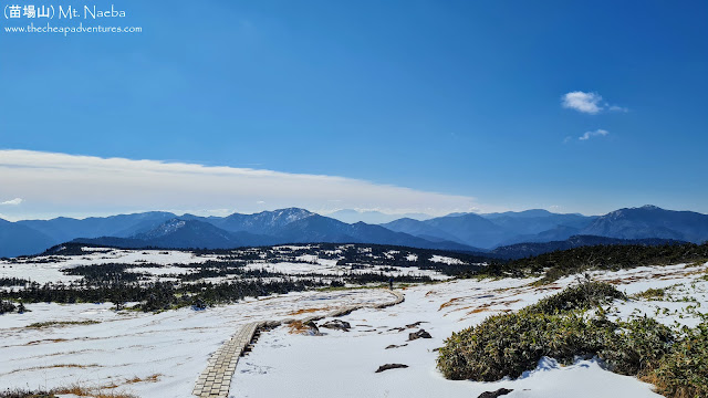
Third try - November 2021, and I've finally summited Mt. Naeba!
Budget: JPY 10,000 (~USD95)
- JPY10,000. Share in car rental, tolls and gas.
- November 7, 2021
- Difficulty: 3 out of 5
- Route below is around 9.1kilometers, with an elevation change of ▲908m/ ▽908m (6h08m)
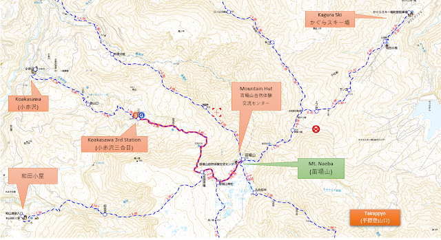
- Map Link
Based on the logs, from early April to latter November.
Special Notes
- Weather forecast: English / Japanese
- Trailheads. Quite a lot, none of them really feasible for public transportation.
- Tairappyo (平標登山口). There are buses from Echigo Yuzawa Station (越後湯沢駅). Summit is about 11 hours one way, 14.2km and 2156 elev gain. There's no camping spot or free mountain hut on the way, so you'll have to fork up JPY5,000 (no meals) to pay for the onsen (赤湯温泉山口館) halfway up.
- Bus schedule in this mess of a website (still can't find where it is), or just use the navitime search. JPY600 one way, takes 34 minutes. First bus at 6am, last bus around 6pm.
- 和田小屋. Doesn't seem to be public transportation for this area. There's a campsite, 栃川高原, that's pretty steep - JPY1,300 per tent, plus JPY500 per person, so around JPY1,800 per solo camper.
- Koakasawa (小赤沢). There should be a bus, but I can't find it. Either way, even if you find a way to the bus stop, take note that you can drive up to here (google maps pin), save yourself 2.5 hours of walking on the road (3.9kms, elev gain of 614m) at which point it's only 3.5hours to the summit.
- 和山温泉入口. There is one or two buses that run everyday, but the earliest you can get at the trailhead is 9:43am (weekdays) or 12:42pm (weekends). It's a 2 hour 20 minute bus from Echigo Yuzawa Station (越後湯沢駅), with a transfer. I can't find any other information but this PDF that was updated last October 2017.
- Mountain huts.
- Paid: 苗場山自然体験交流センター. Right at the summit, JPY6,300 no meals. It is open from June 1 to October 25 (for 2020), and has a capacity of 92 people. Reservations at 080-9987-3693, but it changes by the year so check the link above.
- Free: None.
- Camping: 栃川高原, which is near 和山温泉 trailhead (google maps pin). JPY1,300 for the tent, and then JPY500 per person.
- Wild camping: Parking lot up Koakasawa (小赤沢) (google maps pin), just make sure you're gone before the day's batch of hikers start coming in.
- Side trip: Kiriake Onsen. Famous for having wild onsens in the river.
- Here's the exact spot where I took a dip in the middle of a snowy day. This is where we parked and set up camp.
- For those driving, you can use one of the hotel's numbers 025 767 2252 for car navigation.
Friday
- 09:00pm. Meet up at Tokyo Station, and drive to the trailhead.
- 12:00am. ETA: Koakasawa (小赤沢) up to the parking lot (google maps pin). Setup camp.
- 05:00am. Wake up and tidy up the camp.
- 05:30am. Start hike.
- 09:30am. ETA: Summit. Take a break, eat breakfast.
- 10:30am. Start heading down.
- 01:10pm. ETA: Back at trailhead. Drive back home.


Comments
Post a Comment
Comments are like mail in my postbox. Such a nice surprise. ^__^